Saturday, September 02, 2006

On The Road Again


On The Road Again

Labor Day weekend is one of the busiest periods of time for highway travel. Along with the anticipation of a three day weekend and plans to say goodbye to the record setting '06 summer season comes some sobering statistics. More DUI accidents and fatalities occur during this holiday than any other and 2005 saw deaths on the roadways rise to their highest level in 15 years.

Drive So As To Stay Alive


1. Don't be hasty, think about vehicle safety
- How are your tires, fuel and fluid levels and lights?


2. Once you hit the road, you're in driving mode
- BUCKLE UP!

- Stay focused and alert.
- Limit cell phone use.
- Bring plenty of patience.

3. Stop and think, if your going to drive don't DRINK!
- For that one evening of "bliss", think about this.
- You are being watched, drivers are encouraged to call highway patrol when they observe erratic driving.
- Just before you go to bed, you will always have memories of that accident in your head and when you wake up when the sun begins to rise you will see their face in your eyes.

"Do not look at wine when it exhibits a red color, when it gives off its sparkle in the cup, when it goes with a slickness. At its end it bites just like a serpent, and it secretes poison just like a viper. Your own eyes will see strange things and your own heart will speak perverse things" - Proverbs 23:31-33

Information Instructions:

Scroll over pictures for agency links.


Wednesday, August 30, 2006

Are You Prepared for National Preparedness Month?


ARE YOU PREPARED FOR NATIONAL PREPAREDNESS MONTH?
September will be National Preparedness Month, timing is everything!
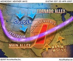
We are in the middle of the Atlantic Hurricane Season on the East Coast,still in the fire season on the West,feeling the earth shake on the Pacific Rim and experiencing severe weather in the Nation's Heartland.
Natural Disasters however are just one aspect of incident preparedness we cannot forget the avian bird flu and CBRNE (Chemical,Biological,Radiological,Nuclear and Explosives) among others.
Prepare to Survive
Keep Yourself and Your Family Alive!
Incident Preparedness starts with a community, a family, an individual, it starts with YOU. It is our personal responsibility to be prepared, we cannot expect government agencies to be our own personal lifejacket. Agencies focus on those who truly cannot help themselves, those that have the ability to initiate their own means of readiness and response are strongly encouraged to do so.
Preparedness need not be overwhelming,draw up your plans,build your kits,conduct a drill and before you know it you'll be ready ...however maintain a sense of urgency and start now.
Scroll over the pictures and you will be directed to a number of agencies that can assist you today.
Do you have pets or livestock? The picture at the top of this blog will take you to the American Veterinary Medical Association.
Do you live in or near San Diego County, California? A link to the County Office of Emergency Services will be helpful.
Be Safe, Be Well, Be PREPARED


Tuesday, August 29, 2006

Have a Safe Flight

"Have a Safe Flight"
The U.S. Department of Transportation’s Bureau of Transportation Statistics says air travel was up 0.9 percent in the first five months this year over the same period a year earlier.
Soon, fall will be here along with increased travel during the holiday season.
The Thanksgiving and Christmas/New Year’s holiday periods are among the busiest long-distance travel periods of the year.
With this in mind let's review some safety suggestions that will make a difference in your life and in the person's seated next to you.
Safety - 1st
Order from the SkyCap Catalog- 2nd
1. Pay Attention to the Preflight Briefing - 10 minutes of your attention may mean your life or the one that you save.
- Carefully read the safety briefing card
- Listen to the Flight Attendants
2. Keep Your Seat Belt Fastened While You are Seated.
- Clear Air Turbulence can be unexpected and can cause serious injuries
3. Don't Drink Too Much - emergencies & alcohol, a mixer you can do without.
- Moderation is a good policy at any altitude.
4. Keep Your Wits About You - Be alert & ready, a prepared passenger is
invaluable!
- Know where the nearest emergency exit is and know how to open it in case of emergency
(refer to the safety briefing card).
For more safety information scroll over the pictures.
Weather Or Not
In aviation, what is icing?
a. found on a cakeplane.
b. flying your plane and eating it too.
c. atmospheric conditions that can lead to the formation of water and ice on the surfaces of an aircraft.
d. what a pilot says when it's going to be an easy landing.

Tropical Storms and The Warnings Given


Tropical Storms

Tropical Storm Watch-A tropical storm watch is issued when tropical storm conditions, including winds from 39 to 73 mph, pose a possible threat to a specified coastal area within 36 hours.

Hurricane Watch-A hurricane watch is issued for a specified coastal area for which a hurricane or a hurricane-related hazard is a possible threat within 36 hours.

Wind and Rain and Floods Oh,My!

Although not at hurricane strength Tropical Storms pack a punch.

THESE RAINS COULD CAUSE LIFE-THREATENING FLASHFLOODS AND MUD SLIDES.

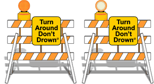
Turn Around, Don't drown!

Floods - On the surface the river of water may look calm but the power lies beneath the surface.

If you are ever swept into the water (may that never happen) look for something to grab on to or float with, look for a way out! Remember it ain't over until the water buffalo sing.

Trapped in a car! look for away out. Ships float,Cars don't

More info

Sunday, August 27, 2006

Hurricane Preparedness - Stay Informed

Hurricane Preparedness
Stay Informed
Knowledge is power,it will enable you to make sound decisions.
"...but the advantage of knowledge is that wisdom itself preserves alive its owners"
When?
Where?
What?
Questions to be answered in the decision and action process.
Reports and Resources
Tropical Storm - An organized system of strong thunderstorms,maximum sustained winds of 39-73 mph
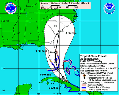
Cnn.com is reporting that Tropical Storm Ernesto is approaching the Dominican Republic. According to a predicted storm/hurricane path T.S. Ernesto will intensify into a hurricane and approach the Florida Keys and the southwestern tip byTuesday, August 29th.
Public Advisory - Tropical cyclone public advisories are intended for the general public in areas threatened by a tropical storm or hurricane.
View the public Advisory at www.nhc.noaa.gov
Learn about hurricanes and other information, afterwards take a test and get a certificate from FEMA: www.meted.ucar.edu/hurrican/chp/hp.htm